Milltown was then called Riverside, in deference to the point of land it occupied at the confluence of the Blackfoot and Clark Fork rivers.
For centuries, Indians had passed nearby on their trail to the buffalo. Their artifacts have been found, in recent years, alongside Milltown Reservoir. Returning east with the Corps of Discovery in 1806, Capt. Meriwether Lewis had followed the rivers a ways. And in November of 1861, road builder John Mullan established his winter encampment at the rivers' junction.
A handful of farmers - the McCormick, Hill, Ray and Davenport families - were the first white settlers in Milltown. John McCormick owned the land that is now Milltown and most of the ground flooded by the building of Milltown Dam.
Workers at Daly's Bonner mill were the first to build homes on the bluff above the rivers. McCormick leased them the lots, and mill managers pretended not to see as lumber disappeared - and homes appeared - "by moonlight."
Bonner and its neatly appointed rows of "company houses" and elegant Hotel Margaret was home to mill managers. Riverside provided the respite for mill workers, many of whom were newly immigrated from Finland, Sweden, Norway and Canada. The old Finn Hall still stands, albeit displaced to West Riverside by the building of Interstate 90 and relegated to storage after many of the Finnish families moved away.
Clark arrived in Riverside a newly elected U.S. senator, monied and powerful. In 1903, McCormick sold the townsite and much of his farm land below the bluff to Clark. In 1905, Daniel Bandmann, a renowned Shakespearean actor and - in his later life - gentleman farmer, sold Clark the 20 acres at the rivers' confluence.
Meanwhile, Clark henchman A.H. Wethey acquired water rights on the Clark Fork and Big Blackfoot, sufficient to operate a power plant. And on Friday, Sept. 13, 1905, construction of "the great Clark dam" began.
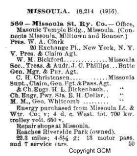
Built of timber cribs filled with rock collected from mountain sides and river banks nearby, the dam was among the largest hydropower plants of its time. The electricity its turbines produced followed two 11,000-volt transmission lines to Missoula and another, smaller line to Daly's sawmill. Clark soon built a sawmill of his own - the Western Lumber Co. - in Milltown and an electric street car line from Missoula to Bonner.
On Friday morning, Jan. 10, 1908, the Missoulian announced the dam's completion and its reservoir's filling:
"The gates of the huge dam were first lowered on Sunday evening. They were lowered in a gradual manner and in the short space of 26 1/2 hours a stream of water 15 inches deep was flowing over the large spillway, while the waters were backed up the Missoula (Clark Fork) River a distance of one and one-half miles, completely inundating land that but a short time ago was used for agricultural purposes.
"The back waters also extend a considerable distance up the Big Blackfoot River, and in one place cover a former county road to the depth of 12 feet. The deepest spot is near the center of the dam, where the water measured 27 feet yesterday afternoon. The total area of the ground covered by the pent-up waters is nearly 600 acres."
Construction superintendent George Slack used the occasion to boast of the building materials consumed by the dam.
"Two million feet of timber were used in the dam proper," he told the newspaper, "while in the concrete work, which is of vital importance, 5,000 barrels of cement found their way. Just how many thousand tons of granite are in the huge dam is a pretty hard question to answer; hundreds of tons of structural steel are also to be found in the great mass of strength that is nearing completion, and when the last piece of timber is added to the dam it will be in such condition that the highest waters ever known in this vicinity will not affect it in the least."
Five months later, Clark's dam was in shambles.
The great flood of 1908 preceded the placement of streamflow gauges on the Clark Fork River. The U.S. Geological Survey, which keeps track of such things, later estimated the flood's flow at East Missoula - 2.8 miles below Clark's dam - at 48,000 cubic feet per second.
Photographs provide the only lasting evidence of the flood's historic extent. In Missoula, every bridge washed away, stranding townspeople north and south of the river. Last to go was the Higgins Avenue Bridge. City engineer Mayo shooed spectators off the span at 10 p.m. on June 5; the bridge washed away an hour later.
In Milltown, water poured over the top of the young dam's northern bulkhead and was deep enough downstream to fill the powerhouse to a depth of 6 feet. Fearing the entire structure would give way and its electrical generating equipment would be lost, Clark's men used dynamite to blow out a section of the crib-work near the river's southern bank.
In a speech at his retirement banquet in December 1910, Wethey said it was three weeks before he could reach the dam, "as the railroads were washed out."
"When I got down, I found the entire river running at the rate of 20 miles an hour through the gap made by the action of the water after the woodwork had been broken up with the dynamite explosion," he said. "I realized our greatest need was to plug up the hole as speedily as possible and get our power plant in operation, and suggested floating in crib-work loaded with rock and sinking them in the opening.
"The work of the repair was done under the superintendence of Mr. Inch, and in 60 days we had plugged up the hole and had the power plant in operation, although it took us more than a year to complete the repairs to the dam that we thought necessary."
Wethey said two of the engineers he brought to Milltown during the repairs suggested he abandon the original dam and build a new one not far below. Wethey continued with the reconstruction.
No less serious were the flood's consequences for Milltown Reservoir, which was ever after filled with more than 6 million cubic yards of sediment carried by the torrent of water. Where the dam created deep pools and large expanses of open water, the flood produced shallow pools - rarely more than a few feet deep - and large acreages of wetlands.
Not long thereafter, complaints about the water in Milltown's wells began. "Water practically surrounds Milltown, and yet it has always been a problem here," Mildred Dufresne wrote in a 1976 history published by the Bonner School Bicentennial Committee. "In early Milltown, there was said to be only one good well. There were a few other wells which did not have very good water. It was thought they were contaminated by the copper mine residue-laden waters of the Clark Fork River."
"It's like your life. You didn't see this coming."
Vic Andersen was the state of Montana's Superfund cleanup coordinator when the first reports of arsenic in Milltown's drinking water came across his desk in 1981. He is the same today.
"At least initially, it didn't matter much where the arsenic was coming from," Andersen said. "We just wanted to find those people a source of clean drinking water."
County sanitarian Ed Zuleger went back to the little houses along Front Street a second time, just in case the first samples had somehow been in error.
Uno Hill lived in one of the original, turn-of-the-century cottages, Zuleger said recently. He was cranky when Zuleger knocked at the door, asking to draw another bottle of water from the kitchen faucet. He balked when Zuleger returned yet again, this time with news of the high arsenic readings.
"I've been drinking this water for 50 years," Hill said. "I don't see any reason to change now."
The water had always tasted kind of funny - metallic, he said. Sometimes, it was discolored. Others in the neighborhood said the same. (The tests also showed high levels of iron and manganese; thus, the metallic taste.)
But no one in Milltown was all that worried, really, and no one - "no way," Zuleger said - imagined all that would follow: Milltown Reservoir's designation as the first Superfund hazardous waste cleanup site in Montana and one of the first in the nation. The upper Clark Fork River's addition to Superfund's National Priority List, along with Butte and Anaconda. The 20 years of research and wrangling.
"Back then, I'd tell my new hires, 'You've got a good five-year run on a project like this,' " Andersen said. "The Milltown cleanup has outlasted most of them. It was always pushed to the back of the stove because it was at the bottom end and everybody kept focusing on the upstream stuff."
It took four years to find and construct a new community water system in Milltown, so cobbled together were the old wells and water lines. In the meantime, health officers found high levels of arsenic in vegetables grown in Milltown gardens - 2.66 parts per million in one spinach sample, 1.41 parts per million in a head of lettuce. Normal, or background, levels for arsenic in vegetables are 0.001 parts per million for spinach and lettuce.
The new Milltown community water system was completed in June of 1985, tapping a clean source of water up the Blackfoot River. And Zuleger - who is still a sanitarian for Missoula's Health Department - went back to the 35 homes on the bluff for one more batch of water samples.
Sixteen taps produced high arsenic readings.
"We ended up putting in new hot water heaters and plumbing in most every house," Andersen said. "Over time, the arsenic had built up in the lines and it was still leaching out, even with clean water. Finally, late in 1985, we got everybody clean water."
And now, finally, comes the time for a decision on what to do about the reservoir sediments that were, indeed, the source of the arsenic in Milltown's drinking water - and about the dam that led to their deposition at the confluence of the Blackfoot and Clark Fork rivers, five miles upstream of Missoula.
"Both Milltown and the Superfund process itself were more complicated than anyone envisioned 20 years ago," said Andersen. "On a site like this, where you are tagging somebody with the bill, it's pure enforcement."
"I'm going to make you clean this up."
"No you're not."
"Yes I am."
"We went through a lot of struggling with a lot of lawyers," he said. Atlantic Richfield Co., successor to the Anaconda Copper Co., was ultimately tagged with the Clark Fork cleanup, including Milltown.
Geologists Moore and Woessner were part of that effort, proving through their research that the "mineral fingerprint" of the sediments in Milltown Reservoir matched those of the mines and tailings in Butte and Anaconda.
Montana Power Co., which purchased Milltown Dam from Clark's estate in 1929, went to Congress and won an exemption from the Superfund cleanup liability. Then the dam itself became part of the debate, most notably after a spectacular ice floe in February 1996 damaged the structure and scoured fish-killing sediments from the reservoir bottom.
Missoula health officers continued their vigil in Milltown and were joined by a growing contingent of state and local politicians. As the cleanup decision neared, their activism intensified into a call for removal of sediments and dam.
Special-interest groups entered the fray, as well. Environmentalists. Economic development committees.
School kids. Whitewater kayakers. Trout lovers. There were billboards likening Milltown Dam to a time bomb and counterpoint bumper stickers proclaiming the structure an historic treasure.
And the Environmental Protection Agency said a cleanup plan will be picked and proposed in 2002. "I actually feel relieved," said John Wardell, chief of the agency's Montana office. "The what ifs are about to go away."
"We always knew that we would eventually come back very actively to the Milltown site," Andersen said. "It took us the better part of 20 years to get here, but the time is right."
The series----
Today: The history of Milltown, its dam and the mining wastes in its reservoir.
Monday: What's wrong with the sediments? Can they be safely removed? What can be learned from other cleanup projects?
Tuesday: A look at Milltown Dam and the problems and possibilities it creates for people and fish. A visit to dam removal sites in Wisconsin.
Wednesday: As a cleanup decision nears for Milltown, a look at dueling politics and personalities.
The filling of the dam will create a large lake and the process will require several days at the present stage of the river. When it is completed, there will be power sufficient to meet the needs of Missoula for a long time, and the plant is so constructed that it can be easily made to furnish additional power whenever the requirements of the city become greater. It is expected by those in charge of the work that the plant at the dam will be ready for use in a week. This is an important day for Missoula; the city will have a supply of electric power second to no municipality in the state.
The first electricity generated at the new power house flashed over the wires at 3:14 o'clock yesterday afternoon, and for a period of several minutes the big plant was brilliantly illuminated.
The interior of the power plant contains six large turbines, which when connected and running to their full capacity, will generate 5,000 horsepower. Two small turbines act independently of the others, and it was these that were operated yesterday. The plant is one of the most substantial ever erected for power purposes. It is absolutely fireproof throughout and is erected upon a concrete foundation sunk to bedrock. The walls of the building, facing the river, are 18 feet thick at the bottom and are of solid concrete, reinforced with hundreds of tons of structural steel.
Stone looks back
Beginning in June of 1911, Missoulian editor Arthur L. Stone wrote a weekly feature titled "Following Old Trails" and providing "historical descriptions of men, places and events of Montana." On one of his first forays, Stone took an afternoon trolley ride from Missoula to Bonner.
The old road dipped down over a steep bank when it reached the river and it climbed up the east bank over a narrow dug road that was literally covered with rolling stones. It was the toughest piece of road I ever saw. Between those two banks, however, nestled the beautiful McCormick ranch, where the sturdy pioneer held the fort and commanded the strategic position which the confluence of the Blackfoot and the Missoula afforded.
Now that ranch is under 10 or 20 feet of water. The big power dam of the Missoula Light and Power company backs up its vast volume of water over the old ranch, over the old road and far up the river.
The road has shifted up the stream to a more comfortable crossing and the big flat which was then a waste now furnishes the sites for the great power plant, for the new mills of the Western Lumber company,
for the delightful Riverside park and for some mighty fine ranches. Since that time, there have been some snug fortunes made from the little farms which lie close under the north hills and which have furnished Bonner with its garden truck and its small fruits.All along the line, there have been changes. From the Missoula end to the Bonner terminus and at each of these places, there have been wonderful transformations. Missoula has multiplied herself by four since then. Bonner has duplicated herself many times. Each has become beautiful, and, between there has been the same splendid development. The transformation has been great but it is only an indication of what may come; it just outlines the possibilities.